Austin Drone Surveying Services
Companies that don’t take advantage of the time and cost savings associated with Austin drone surveying services are shortchanging themselves. At Lone Star Drone, we have a great deal of experience in this area, and we have the best pilots and the best equipment. Our drone surveying services in Austin TX are incredibly precise, and incredibly efficient. If you’re ready to reap the benefits, get in touch with us as soon as you can to learn more.
What is a Drone Survey?
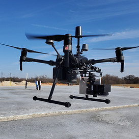
Austin drone surveying services simply refer to the use of an unmanned aerial vehicle, commonly referred to as a drone. The drone is outfitted with cameras and sensors, which they use to photograph land or an object. The images captured by those cameras are then used in conjunction with special software to produce detailed maps, available in either two or three dimensions.
Unlike using helicopters or airplanes, companies that use drone surveying services in Austin TX obtain data this is just as precise, and they get it much faster. They also pay a fraction of the price. Manned aircraft might be limited by issues such as cloud cover. Drones can fly at a much lower altitude, so they’re not at the mercy of the elements to the same degree.
Benefits of Drone Surveys
There are a lot of advantages to drone surveying services in Austin TX. These are just some of the most important ones.
-
Cost and time savings – You can obtain the topographic data you need up to five times faster than using land-based processes. You’ll also need much less manpower.
-
Accurate data – A single drone flight can deliver thousands of different pieces of data that can be represented in a wide range of formats.
-
Accessibility – The drones used in surveying can launch from just about any position. Traditional measuring tools are often limited due to challenges such as harsh terrain that features steep slopes. Drones aren’t faced with those limits. Also, there will be no need to shut down railroad lines or highways.

Please contact Lone Star Drone for more information on Austin drone surveying services. You can use our online form, or you can call 817-642-7499.