Mapping and Survey

Beyond Precision
In the past, mapping and survey work took scores of teams working long hours. The maps that were produced were expensive and could take weeks or months to get into the hands of those who needed them.
If a project is happening in real time, shouldn't the maps and surveys be equally as quick? Projects and proposals can change from day to day and you need the data to make decisions and delegate resources accordingly. Lone Star Drone can help you see what you need to see within hours.
What we do...
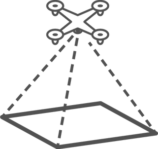
Aside from photography, mapping is the single most common use for drone. The truth is, however, 90% of the drone companies offering topo, planimetrics and land use survey maps are incapable of giving industry standard drone solutions. To get centimeter or sub-centimeter results, secondary positioning calibration equipment has to be used. We have seen it happen time after time, a drone company is hired, they show up with nothing but their drone, fly a few passes over their target, and then a few weeks later an inaccurate "map" is delivered. Lone Star Drone does it right the first time. Our equipment is industry leading, allowing us to offer services that satisfy any need, and requirement, and in faster time than the competition.
When accuracy is key, we employ the use of Trimble GNSS system to determine ground control points within the defined area. These systems are industry standard centimeter and sub-centimeter survey systems. Once the GCPs have been established, our drones will fly their mission , assisted by RTK or PPK calibration rovers. In post processing, we will use the ground control points to calibrate the produced map. This achieves incredible accuracy once only possible with an entire survey team and weeks of on the ground time.

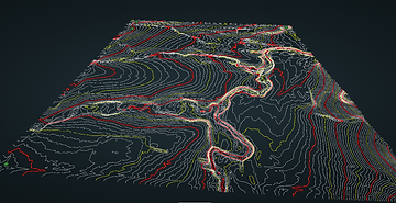
LiDAR
Everyone is talking about LiDAR these days. When precision, speed, and area coverage matters, LiDAR delivers. Lone Star Drone has perfected the process of collecting, processing, and delivering LiDAR data to our clients exact standards.


Land and Project Modeling
When a property has not been developed, it is hard to visualize what exactly the end product will look like. Where to place the structures, how much earth will have to be moved, or simply what will the view be like, are all questions that traditional methods of planning cannot answer.
Using the data our drones capture, we can create lifelike models to use in build and project renderings. This can be useful if clients are unsure where they want to build to best utilize land, or simply where to place their future house to get the best view of the lake.
We are seeing the future take shape all around us. Not utilizing technology in the most imaginative way possible is a waste. With all that computer and drones can do, allow Lone Star Drone to use technology in the best way possible.

As captured by the LiDAR system.

Bare earth model.
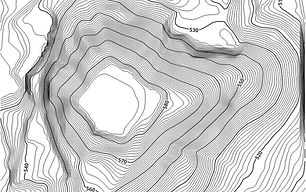
Final topo map created.
Creating a proper topographic survey requires a great deal of attention to detail. We have perfected the capability to produce world class surface models and topo maps.

3D model of new home construction

Ortho/Cadastral hybrid survey
- Build Models
- Project Renderings
- Virtual Reality
-Incredible GSD
- Project Renderings
- Digital Twin building

RTK Ground Station

Urban Planning Survey

Topography Mapping
Topographic Work
Topographic modeling has become a mainstay of property/land development. Importing a surface model into CAD will create the most precise topo survey possible. The thing is, it has to be done right. Unfortunately, there are a lot of people out there who don't have either the drone experience or the survey backgrounds, or both. This can create an unreliable dataset.
LS Drone on the other hand, brings years of experience and certifications, allowing our clients to trust the data they receive. Put simply, no client we have ever worked with has not been completely satisfied with the data they get. We would love to show you how we can take your project to the next level. We are so confident that you will be satisfied, we will do a free topo for you. If you don't like what you see, you don't pay. Call or email us anytime to schedule a demo or topo job!